
 David L. Bright graciously permitted me to summarize some of the information from his comprehensive website, Confederate Railroads. Most of the railroads in the table below have a map number identifying them on the eastern or western map from Black’s Railroads of the Confederacy, which can be found on the Confederate Railroads site under “Maps” (http://csa-railroads.com/). Mr. Bright noted, however, that “research is ongoing and the numbers on your sheet are subject to being overtaken by new data. . . . If exact data is important, my site should be checked to see if information has been changed/updated.”
A spreadsheet containing this table, with extensive notes for the railroads and other tabs listing the stations and mileage of several of the most important lines can be found here.
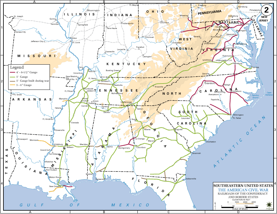
The contents of his site are copyrighted. The data below, on the spreadsheet, and on his site may be used for non-commercial purposes as long as credit is given to David L. Bright and the address of the site is given (www.csa-railroads.com). The map pictured above is from the West Point Atlas of American Wars.
| Map# | Name | State | Gauge | Miles | Engines | Cars | Stns | Terminus | Terminus |
| 1 | Baltimore & Ohio | MD | |||||||
| 2 | Alexandria, Loudoun & Hampshire | VA | 4′ 8″ | 38 | 3 | 49 | 11 | Alexandria | Leesburg |
| 3 | Orange & Alexandria | VA | 4′ 8″ | 115 | 16 | 191 | 36 | Alexandria | Lynchburg |
| 4 | Winchester & Potomac | VA | 4′ 8″ | 35 | 5 | 53 | 8 | Harpers Ferry | Winchester |
| 5 | Virginia Central | VA | 4′ 8″ | 195 | 28 | 247 | 39 | Richmond | Jackson’s River |
| 6 | Richmond, Fredericksburg & Potomac | VA | 4′ 8″ | 79 | 11 | 216 | 20 | Richmond | Aquia Creek |
| 7 | Richmond & York River | VA | 4′ 8″ | 38 | 4 | 51 | 12 | Richmond | Westport (at West Point) |
| 8 | Richmond & Petersburg | VA | 4′ 8″ | 28 | 10 | 207 | 8 | Richmond | Petersburg |
| 9 | Richmond & Danville | VA | 5′ | 156 | 23 | 398 | 27 | Richmond | Danville |
| 10 | South Side | VA | 5′ | 136 | 20 | 311 | 18 | City Point | Lynchburg |
| 11 | Norfolk & Petersburg | VA | 5′ | 85 | 6 | 98 | 13 | Petersburg | Norfolk |
| 12 | Petersburg | VA | 4′ 8″ | 81 | 13 | 180 | 11 | Petersburg | Weldon |
| 13 | Seaboard & Roanoke | VA | 4′ 8″ | 80 | 10 | 174 | 13 | Portsmouth | Weldon |
| 14 | Virginia & Tennessee | VA | 5′ | 224 | 39 | 406 | 38 | Lynchburg | Bristol |
| 15 | Piedmont | NC | 4′ 8″ | 48 | 0 | 0 | 6 | Greensboro | Danville |
| 16 | Raleigh & Gaston | NC | 4′ 8″ | 100 | 13 | 171 | 17 | Raleigh | Weldon |
| 17 | Roanoke Valley | NC | 4′ 8″ | 22 | 2 | 14 | 3 | Clarksville | Manson or Junction |
| 18 | Wilmington & Weldon | NC | 4′ 8″ | 191 | 26 | 182 | 28 | ||
| 19 | Atlantic & North Carolina | NC | 4′ 8″ | 96 | 6 | ~55 | 17 | Morehead City | Goldsboro |
| 20 | North Carolina | NC | 4′ 8″ | 240 | 23 | 313 | 29 | Charlotte | Goldsboro |
| 21 | Western North Carolina | NC | 4′ 8″ | ~84 | 5 | 45 | 12 | Salisbury | Head of the Road |
| 22 | Western | NC | 4′ 8″ | 44 | 3 | ~60 | 7 | Fayetteville | Egypt |
| 23 | Atlantic, Tennessee & Ohio | NC | 5′ | 47 | 0 | 0 | 8 | Charlotte | Statesville |
| 24 | Wilmington, Charlotte & Rutherford | NC | 4′ 8″ | 149 | 7 | 126 | 25 | Wilmington-Old Hundred | Charlotte-White Pine (Cherryville) |
| 25 | Wilmington & Manchester | SC | 5′ | 173 | 24 | 206 | 23 | Wilmington | Kingsville |
| 26 | Cheraw & Darlington | SC | 5′ | 40 | 4 | 47 | 6 | Florence | Cheraw |
| 27 | Charlotte & South Carolina | SC | 5′ | 110 | 15 | 156 | 19 | Columbia | Charlotte |
| 28 | King’s Mountain | SC | 5′ | 24 | 2 | ? | 10 | Chester | Yorkville |
| 29 | South Carolina | SC | 5′ | 242 | 62 | 849 | 55 | Charleston | Augusta |
| 30 | Greenville & Columbia | SC | 5′ | 169 | 24 | 187 | 31 | Columbia | Greenville |
| 31 | Spartanburg & Union | SC | 5′ | 68 | ? | ? | 22 | Spartanburg | Alston |
| 32 | Laurens | SC | 5′ | 34 | ? | ? | 7 | Newberry | Laurens |
| 33 | Blue Ridge | SC | 5′ | 35 | 3 | 36 | 5 | Anderson | Walhalla |
| 34 | Northeastern | SC | 5′ | 103 | 13 | 156 | 17 | Florence | Charleston |
| 35 | Charleston & Savannah | SC | 5′ | 110 | 12 | 139 | 18 | Charleston | Savannah |
| 36 | Georgia | GA | 5′ | 247 | 56 | 700 | 29 | Augusta | Atlanta |
| 37 | Augusta & Milledgeville | GA | 5′ | ||||||
| 37 | Milledgeville Railroad | GA | 5′ | 7 (or 10) | 0 | 0 | 2 | Warrenton | Ogeechee River |
| 38 | Western & Atlantic | GA | 5′ | 138 | 46 | 726 | 24 | Chattanooga | Atlanta |
| 39 | Etowah | GA | 5′ | 5 | 0 | 0 | 2 | Etowah | Junction |
| 40 | Rome | GA | 5′ | 21 | ? | ? | 6 | Rome | Kingston |
| 41 | Central (of Georgia) | GA | 5′ | 282 | 60 | 732 | 37 | Savannah | Macon |
| 42 | Macon & Western | GA | 5′ | 108 | 19 | 187 | 20 | Macon | Atlanta |
| 43 | Upson County | GA | 5′ | 17 | 1 | 1 | 4 | Barnesville | Thomaston |
| 44 | Macon & Brunswick | GA | 5′ | 38 | 2 | 7 | 8 | Macon | Cochran |
| 45 | South Western | GA | 5′ | 208 | 22 | 238 | 33 | Macon | Chattahoochee |
| 46 | Muscogee | GA | 5′ | 50 | 8 | 112 | 8 | Butler | Columbus |
| 47 | Augusta & Savannah | GA | 5′ | 63 | 5 | 66 | 10 | Augusta | Millen |
| 48 | Savannah, Albany & Gulf | GA | 5′ | 72 | 11 | 206 | 24 | Savannah | Thomasville |
| 49 | Atlantic & Gulf | GA | 5′ | 158 | 0 | 0 | 0 | N/A | N/A |
| 50 | Brunswick & Florida (or Albany) | GA | 5′ | 65 | 2 | 7 | 3 | Brunswick | Saltilla |
| 51 | Atlanta & West Point | GA | 5′ | 87 | 19 | 131 | 12 | Atlanta | West Point |
| 52 | Florida, Atlantic & Gulf Central | FL | 5′ | 67 | 3 | =>25 | 6 | Jacksonville | Lake City |
| 53 | Florida | FL | 5′ | 156 | 10 | 46 | 20 | Fernandina | Cedar Keys |
| 54 | Pensacola & Georgia | FL | 5′ | 157 | 6 | ? | 15 | Gee’s Turnout | Lake City |
| 55 | Tallahassee | FL | 5′ | 21 | 2 | ? | 3 | St. Marks | Tallahassee |
| 56 | Alabama & Florida (of Florida) | FL | 5′ | 47 | 5 | 26 | 14 | Pensacola | State Line |
| 57 | Alabama & Florida (of Alabama) | AL | 5′ | 116 | 11 | 81 | 10 | Montgomery | State Line |
| 58 | Montgomery & Eufaula | AL | 5′ | ~10 | 1 | ? | 2 | Montgomery | End of Road |
| 59 | Montgomery & West Point | AL | 4′ 8″ | 127 | 22 | 306 | 22 | West Point | Montgomery |
| 60 | Tuskegee | AL | 4′ 8″ | 6 | ? | ? | 2 | Chehaw | Tuskegee |
| 61 | Mobile & Girard | AL | 5′ | 57 | 4 | ? | 9 | Girard | Union Springs |
| 62 | Mobile & Great Northern | AL | 5′ | 52 | 1 | ? | 8 | Tensas | Pollard |
| 63 | Spring Hill | AL | 5′ | N/A | N/A | N/A | N/A | N/A | N/A |
| 64 | Mobile & Ohio | MS | 5′ | 499 | 68 | 823 | 80 | Mobile | Columbus, Ky |
| 65 | Mississippi, Gainesville & Tuscaloosa | AL | 5′ | 22 | 0 | 0 | 5 | Gainesville | Junction (Narkeeta) |
| 66 | Memphis & Charleston | TN | 5′ | 311 | 50 | 805 | 40 | Memphis | Stevenson |
| 67 | Wills Valley | GA | 5′ | 20 | 2 | 4 | 3 | Wauhatchie | Trenton |
| 68 | Nashville & Chattanooga | TN | 5′ | 255 | 37 | 380 | 32 | Nashville | Chattanooga |
| 69 | Winchester & Alabama | TN | 5′ | 38 | 1 | ? | 5 | Decherd | Fayetteville |
| 70 | McMinnville & Manchester | TN | 5′ | 37 | 0 | 0 | 7 | McMinnville | Tullahoma |
| 71 | Central Southern [part of 71] | TN | 5′ | 46 | ? | ? | 10 | State Line | Columbia |
| 71 | Nashville & Decatur | TN | 5′ | N/A | N/A | N/A | N/A | ||
| 71 | Tennessee & Alabama [part of 71] | TN | 5′ | 49 | 5 | 36 | 10 | Columbia | Nashville |
| 71 | Tennessee & Alabama Central [part of 71] | AL | 5′ | 29 | ? | ? | 7 | Decatur | State Line (Veto) |
| 72 | Nashville & Northwestern | TN | 5′ | 79 | 6 | ? | 18 | Nashville-Kingston Springs | Hickman-McKenzie |
| 73 | Louisville & Nashville | TN | 5′ | 285 | 38 | 342 | 82 | Louisville | Nashville |
| 74 | Memphis, Clarksville & Louisville | TN | 5′ | 83 | 4 | ? | 21 | Paris, Tenn | Guthrie |
| 75 | Edgefield & Kentucky | TN | 5′ | 38 | 3 | =>14 | 7 | Edgefield Junction | Guthrie, Ky. |
| 76 | East Tennessee & Georgia | TN | 5′ | 148 | 22 | 171 | 22 | Knoxville | Dalton |
| 77 | East Tennessee & Virginia | TN | 5′ | 135 | 17 | 157 | 21 | Bristol | Knoxville |
| 78 | Knoxville & Kentucky | TN | 5′ | 10 | 1 | ? | 2 | Knoxville | near Beaver Creek |
| 79 | Rogersville & Jefferson | TN | 5′ | 16 | 2 | ? | 3 | Holston River | Junction |
| 80 | Memphis & Ohio | TN | 5′ | 134 | 13 | =>247 | 20 | Memphis | Paris, Tenn |
| 81 | Northeast & Southwest Alabama | AL | 5′ | 27 | 0 | 0 | 3 | Meridian | York |
| 81 | Northeast & Southwest Alabama | MS | 5′ | 27 | 0 | 0 | 3 | Meridian | York |
| 82 | Alabama & Mississippi Rivers | AL | 5′ | 104 | =>3 | =>21 | 21 | Selma | Marion/Reagan |
| 82 | North Western Railroad of Alabama | AL | 5′ | 11 | 0? | 0? | 2 | Uniontown | New Bern, Ala |
| 82 | Selma & Meridian | AL | 5′ | 104 | =>2 | =>21 | 21 | Selma | Marion/Reagan |
| 83 | Cahaba, Marion & Greensboro | AL | ? | 27 | 2 | =>29 | 11 | Cahaba | Marion |
| 84 | New Orleans & Ohio | TN | 5′ | 61 | ? | ? | 10 | Paducah | Union City, Tenn |
| 85 | Mississippi Central | MS | 5′ | 255 | 35 | 358-555 | 30 | Canton | Jackson, Tenn |
| 86 | Mississippi & Tennessee | MS | 5′ | 105 | 7 | 124 | 17 | Memphis | Grenada |
| 87 | Memphis & Little Rock | AR | 5′ 6″ | 86 | =>4 | ? | 9 | Hopefield-Argenta | Little Rock- Devall’s Bluff |
| 88 | New Orleans, Jackson & Great Northern | MS | 5′ | 206 | 45 | 607 | 24 | New Orleans | Canton |
| 89 | Southern (of Mississippi) | MS | 5′ | 140 | 18 | >96 | 21 | Vicksburg | Meridian |
| 90 | Raymond | MS | 5′ | 7 | ? | ? | 2 | Bolton | Raymond |
| 91 | Jefferson & Lake Pontchartrain | LA | 4′ 8″ | 6 | ? | ? | ? | Unknown | Unknown |
| 92 | Pontchartrain | LA | 4′ 8″ | 6 | ? | ? | 2 | New Orleans | Milneburg (Lakeport) |
| 93 | Mexican Gulf | LA | 5′ | 28 | 3 | ? | 6 | New Orleans | Proctorville |
| 94 | New Orleans, Opelousas & Great Western | LA | 5′ 6″ | 83 | 12 | 228 | 16 | Algiers | Brashear |
| 95 | West Feliciana | LA | 4′ 8″ | 28 | 5 | =>16 | 6 | Bayou Sara | Woodville |
| 96 | Clinton & Port Hudson | LA | 4′ 8″ | 27 | 1 | 7 | 4 | Clinton | Port Hudson (Ronaldson’s Landing) |
| 97 | Baton Rouge, Grosse Tete & Opelousa | LA | 5′ 6″ | 29 | 3 | 17 | 5 | West Baton Rouge | Livonia |
| 98 | Vicksburg, Shreveport & Texas | LA | 5′ 6″ | 80 | 6 | 67 | 19 | Desoto-Monroe | Shreveport-Head of the Road |
| 99 | Alexandria & Cheneyville | LA | 5′ | N/A | N/A | N/A | N/A | N/A | N/A |
| 99 | Red River | LA | 5′ | 16 | 1 | Very few | 3 | Alexandria | Bayou Boeuf (Lecompte) |
| 100 | Texas & New Orleans | TX | 5′ 6″ | 111 | 4 | 67 | 9 | Houston | Madison or Orange |
| 101 | Eastern Texas | TX | 5′ 6″ | 28 | 2 | 14 | 3 | Beaumont | Sabine City |
| 102 | Buffalo Bayou, Brazos & Colorado | TX | 4′ 8″ | 83 | 6 | >96 | 6 | Harrisburg | Alleyton |
| 103 | Houston Tap & Brazoria | TX | 4′ 8″ | 50 | 2 | 35 | 8 | Houston | East Columbia |
| 104 | Galveston, Houston & Henderson | TX | 5′ 6″ | 50 | 5 | 63 | 9 | Galveston | Houston |
| 105 | Houston & Texas Central | TX | 5′ 6″ | 83 | 7 | 99 | 10 | Houston | Millican’s |
| 106 | Washington County | TX | 5′ 6″ | 25 | 1 | 18 | 3 | Hempstead | Brenham |
| 107 | San Antonio & Mexican Gulf | TX | 5′ 6″ | 27 | 3 | 41 | 3 | Port Lavaca | Victoria |
| 108 | Memphis, El Paso & Pacific | TX | ? | 5 | 1 | 10 | 2 | Jefferson | Moore’s Landing |
| 109 | Southern Pacific | TX | 5′ 6″ | 27 | 3 | 6 | 8 | Marshall | Greenwood |
| 110 | Manassas Gap | VA | 4′ 8″ | 90 | 9 | 232 | 20 | Junction | Mount Jackson |
| 111 | Alabama & Tennessee River | AL | 5′ | 138 | 6 | 146 | 38 | Selma | Blue Mountain |
| 112 | Hungary Branch | VA | 4′ 8″ | 4 | 0 | 0 | 2 | Junction | Springfield Coal Pitts |
| 113 | Grand Gulf & Port Gibson | MS | 4′ 8″ | 8 | ? | ? | 2 | Grand Gulf | Port Gibson |
| N/A | Alabama Coal Company | AL | 5′ | 3 | ? | ? | 1 | Junction | Alabama Coal Company |
| N/A | Clover Hill | VA | 4′ 8″ | 22 | 0 | 0 | 3 | Junction | Clover Hill |
| N/A | Gordon’s Mine Railroad | GA | 5′ | ||||||
| N/A | Montevallo Coal Company | AL | ? | ? | ? | ? | 1 | Junction | Montevallo Coal Company |
| N/A | New Orleans & Carrollton | LA | 4′ 8″ | 6 | 9 | 54 | 2 | New Orleans | Carrollton |
| N/A | Nicojack | GA | 5′ | 8 | ? | ? | 2 | Gordon’s Mine | Shellmound |
| N/A | Pensacola & Mobile | FL | 5′ | 6 | ? | ? | 2 | Perdido River | Junction |
| N/A | Shelby Coal Company | AL | ? | 4? | 0? | 0? | 1 | Junction | Shelby Coal Company |
| N/A | Shelby Iron Company | AL | 5′ | 6 | 0 | 0 | 1 | Columbiana | Shelby Iron Company |
| N/A | South & North Alabama | AL | 5′ | 17 | 0 | 0 | 3 | Calera (Lime Kiln) | Cahaba River and Cahaba Coal Mines |
| N/A | St. Johns | FL | ? | 16 | ? | ? | 2 | St. Augustine | Tocoi |
| N/A | Tennessee Coal & Railroad | TN | 5′ | 20 | 2 | =>36 | 3 | Tracy City | Junction |
| N/A | Tuckahoe & James River | VA | ? | 5 | ? | ? | 2 | Coal Pits | James River |